


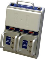
The MALÅ ProEx system is a truly modular and lightweight full-range Ground Penetrating Radar (GPR) system designed to meet the needs of the advanced professional user. At the heart of this new system is the MALÅ ProEx Control Unit. Designed on a completely new technical platform, the MALÅ ProEx is the most versatile control unit in the MALÅ Geoscience range.
The interchangeable features of the MALÅ ProEx make it available as a single or dual-channel system in the basic configuration, or a true multi-channel system with the optional expansion units. The MALÅ ProEx is fully compatible with all antennas from MALÅ Geoscience, offering configurations between 25 MHz to 2.3 GHz, with up to 16 simultaneous recording channels.
Ethernet communications between the MALÅ ProEx and the MALÅ XV Monitor or a notebook PC ensure safe and reliable data transfer at high speed. Depending on the configuration and the antennas used, the MALÅ ProEx can perform various measurements, including standard reflection surveys, tomography, or velocity (CMP) measurements.
Applications
|
• Archaeological Site Assessment |
• Location of ancient buildings, foundations and related vestiges |
|
• Avalanche control |
• Location of hidden weapons or evidence |
|
• Bathymetry studies |
• Measure bridge deck thickness |
|
• Bridge deck condition assessment |
• Measure slab thickness |
|
• Buried goods, clandestine grave location |
• Military |
|
• Cemetery mapping |
• Polar research |
|
• Concrete inspection |
• River & lake bottom profiling |
|
• Condition assessment |
• Sedimentological studies |
|
• Cultural Resource Management |
• Site assessment |
|
• Damage prevention |
• Site monitoring |
|
• Deep bedrocks profiling |
• Site Monitoring |
|
• Determining concrete cover depth on new structures |
• Snow thickness |
|
• Environmental remediation |
• Soil & aggregate mapping |
|
• Excavation planning |
• Structure inspection |
|
• Fractures characterisation |
• Turf assessment |
|
• Glacier investigations |
• Underground mining mapping |
|
• Groundwater resources |
• Underground Storage Drums location |
|
• Groundwater resources |
• Underground Storage Tank (UST) location |
|
• Hazardous waste site assessment |
• Unexploded Ordnance (UXO) detection |
|
• Ice thickness |
• Utility detection |
|
• Inspection of other reinforced concrete structures |
• Utility positioning |
|
• Karst mapping |
• Void detection and location |
|
• Landfills delineation |
• Void location |
 Print
Print Sent by email