


ABEM Terrameter LUND Imaging System – Automatic System for Resistivity and IP Imaging - has been designed for optimum versatility in infrastructure projects and environmental studies.
Built-in quality control and feedback to operator.
Automated roll-along capability for 2D and 3D surveys.
High productivity rate thanks to speed-optimised software (particularly in 4 channel version).
Electrical Imaging
Electrical imaging has emerged as a prime method for infrastructure projects and environmental studies in recent years, and the demand for better information is expected to continue. In such applications the following essential:
- High resolution at shallow depths.
- Automated data acquisition for cost effectiveness.
- Superior area coverage through at least two dimensional information.
- Output presented in easily interpretable form.
The ABEM Terrameter LUND Imaging System, developed in cooperation with Dept. of Engineering Geology, Lund University, provides fast, accurate and automated resistivity imaging in 2D and 3D. The entire data handling process is automated as far as possible, including data acquisition, processing, interpretation and presentation.
This is made possible by utilising state of the art technology.
Key features of the LUND Imaging System
Integrated roll-along function.
Automatic electrode contact test.
Option to measure IP.
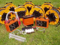
System Components
Terrameter SAS1000 (single channel) or SAS4000 (four channel) resistivity and IP instrument, with integrated PC for full control of data acquisition process and storage of data. Built-in transmitter with maximum ±400 V (800 V peak-to-peak) and 1000 mA output. 12 V DC power supply.
Electrode Selector ES10-64e or ES10-64 connects to the Terrameter through a single robust cable. Power supply via the Terrameter.
Terrameter and Electrode Selector housed in rugged waterproof (IP66) aluminium housing for reliable performance during harsh field conditions.
Field cable set with electrodes and cable jumpers. Highly durable multi-conductor cable terminated both ends with military standard connectors.
User-friendly acquisition and presentation software for standard or user defined arrays.
Major advantages
A major advantage of the method is that it produces continuous images of the variation in properties in the subsurface. Electrical imaging can serve as an excellent basis for planning detail investigations via for example a drilling and sampling programme with optimised sampling locations. The detail investigation results can then in turn be used as a base for a refined interpretation of the electrical imaging data, leading to a comprehensive and reliable model of the underground
Typical areas of application
- Groundwater resource management and vulnerability assessment,
- Mapping and monitoring of contaminated ground/groundwater
- Geotechnical pre-investigation
- Geological mapping
- Mapping/prospecting of natural resources
- Geothermal prospecting
- Sub-bottom mapping at sea and in lakes
- Mapping of frozen ground/permafrost
- Archaeology
- Resistivity Imaging a Robust Method
Resistivity imaging is a robust method, which often produces good results even close to for example power lines and railways, in contrast to EM methods that are mostly useless near such installations. It is, however, important to realise that disturbances can occur, and that false anomalies can arise from for example metal pipes of other conductive objects in the ground.
The method is well suited for long term monitoring. A series of measurements taken at different times can give information about variations in water content, movement of pollutants in the ground, seepage through embankment dams etc.
Automated data acquisition allows a field crew to carry out complementary investigations during measurement (e.g. levelling, GPS positioning). However, the 4 channel version of the system offers very high field productivity; in standard electrical imaging it means that the major limiting factor is the pace of work of the field crew rather than the equipment.
 Print
Print Sent by email